


Page 5 - Demo
P. 5
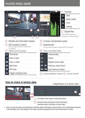
When you play the video, three-dimensional coordinate system information (G-sensor data) on the X-axis(progress direction), Y-axis (left-right), and Z-axis (height) of the image currently being played at the G-sensor data location is output.How to check G-sensor data%u0012%u0013The location of the image currently being played Numerical values and graphs of three-dimensionalcoordinate system information (G-sensor data)PLAYER MENU NAME%u0016%u0017 %u0018%u0012%u0013%u0014Tool Box%u0013 Google Map%u0014 Playlists and Information Display %u0017 G-sensor (acceleration) graph%u0015 GPS reception windowSaveOpen FolderPrintSetting%u0019 %u001a %u0012%u0011It can be used only when an external GPSis connected.When GPS and internet areconnected, it will work normally.%u0018 SpeedometerIt can be used only when an external GPS is connected%u0012%u0016 7JEFP%u0001DPOUSPM%u0001QPQVQThumbnailDraw a laneView a videoSplit ViewPIP ViewToggle (change) color%u0019 1MBZ%u0001B%u0001SFDPSEFE%u0001WJEFP%u001a \4PVOE%u0001DPOUSPMforward playPauseRepeat event videoPrevious, Next Eventplay frame by frame%u0015%u0013%u0012


